Tulum Ruins: One of the Last Maya Sites
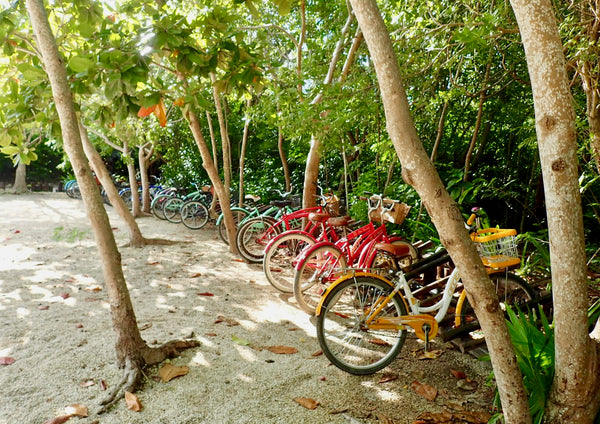
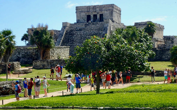
In 2018 the spectacular ruins of Tulum became the second most visited archeological site in Mexico surpassing Chichén Itzá. Over seventy-five percent of the annual visitors are foreigners. Cody and I visited the Yucatán peninsula in late October for our honeymoon enjoying the turquoise crystal waters of the Caribbean Sea. We stayed in a cozy coastal cabana on a private cove inside Tulum National Park. On our 3rd day, we grabbed 2 beach cruiser bicycles and pedaled a couple kilometers through the jungle-covered mangroves to the entrance of Tulum ruins.
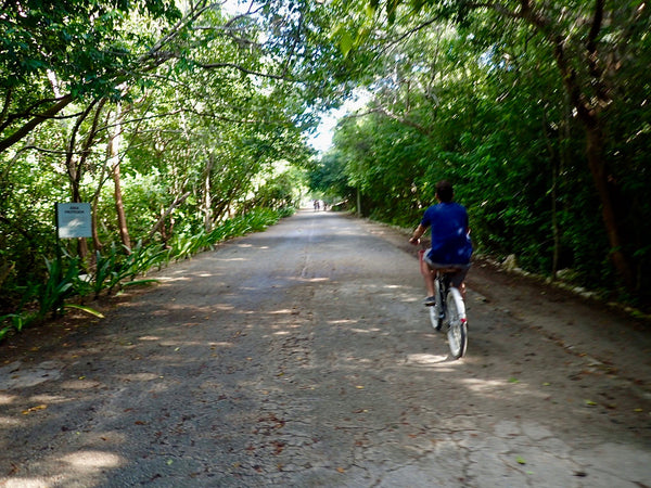
To avoid crowds, stay at a hotel inside Parque Nacional Tulum to arrive earlier than the tour groups and busses.
When the first explorers sailed past the eastern coasts of the Yucatán peninsula 500 years ago, a shallow reef system protected the coastline limiting access. By the time the Spanish arrived in the New World, the great Maya political complexes of the Classical period had dissolved leaving the magnificent cities abandoned and dividing the remaining native people into smaller warring provinces. The location of the splendid coastal fortress of Tulum perched atop cliffs and surrounded by a 5-meter thick defense wall fostered the establishment of a powerful Postclassic Maya city-state controlling maritime commerce from the Gulf of Mexico to Honduras.
The Temple of the Wind is believed to have aided in the maneuvers of embarking and disembarking canoes visiting a central marketplace located at Tulum.
Tales of gold and other riches encouraged the adventures of the early Spanish conquistadors. In 1518, Juan Diaz, aboard a Spanish ship, describes the first European encounter of the coastal watchtowers and impressive pyramid city of Tulum as he sails past in the azure waters while writing the Itinerary of the navy of the Catholic King to the island of Yucatan, in India, the year 1518 (translated below.)
Friday to May 7- We began to discover the island of Yucatan.- This day we left this island called Santa Cruz, and we went to the island of Yucatan crossing fifteen miles of gulf. Arriving at the coast we saw three large towns that were separated about two miles from each other, and you could see in them many stone houses and very large towers, and many thatched houses. We would like to enter these places if the captain had allowed it; but having denied it, we ran day and night along this coast, and the next day, near the sunset, we saw very far a town or village so big, that the city of Seville could not seem greater or better; and there was a very large tower in it. Many Indians walked along the coast with two flags that rose and fell, signaling us to come closer; but the captain did not want to. This day we came to a beach that was next to a tower, the highest we had seen, and we could see a very large town; there were many rivers on the land. We discovered a wide entrance surrounded by logs, made by fishermen, where the captain went down to land; and in all this land we do not find where to continue coasting or move on; so we made sail and we went out where we had entered.
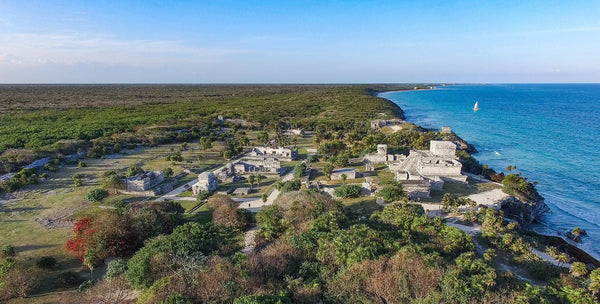
Tulum in 2018 is pictured from above looking to the northeast. The native name of the site is believed to be Zama or 'Dawn' reflecting the east-west alignment of the buildings. Photo by Dronepicr, wikimedia.org
.jpeg#/media/File:Tulum_Maya_Ruins_(213574097).jpeg)
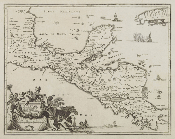
Map of Mesoamerica in the year 1671 (wikimedia.org). More than 150 years after the first written account of Tulum, the eastern Yucatán coast remains unknown. There are no known records of the site until 1840 when an inspector for the Spanish crown, Jose de Galvez, gathered information for a royal policy to increase crown revenues.
The shallow reef system protecting the Maya inhabitants from the Spanish explorers is known as the Mesoamerican reef and stretches from the northern tip of the Yucatán peninsula to the Gulf of Honduras. Tulum's location afforded the stone fortress control of both coastal and Yucatán land routes. Large canoes traveled the sea and an extensive river system marked by temples and towers functioning as navigational aids and in locating fresh water sources. Trade items from all over Mesoamerica have been found at the coastal archeological site including jade from Guatemala, copper, gold, turquoise, and obsidian from the mountains of Mexico, with salt and lime powder as the primary goods of exportation from the Yucatán. As the goods flowed, so did the exchange of ideas resulting in a cultural diffusion that is represented in the architecture, art, and belief systems of the late Maya.
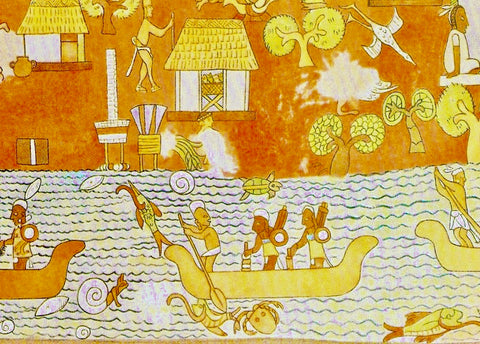
A Maya mural depicting maritime trade at the nearby site of Chichén Itzá.
The walled city of Tulum was believed to be ruled by a priestly class due to the large number of shrines, altars, temples, and spiritual murals found throughout the site. The surrounding wall is believed by historians to be a social class barrier rather than a defense wall. As the Maya dynastic families of the Classical period lost power due to drought, famine, fires, and war, a new ruling class emerged in the Postclassic period wielding power through religion and sacrifice to appease the gods.
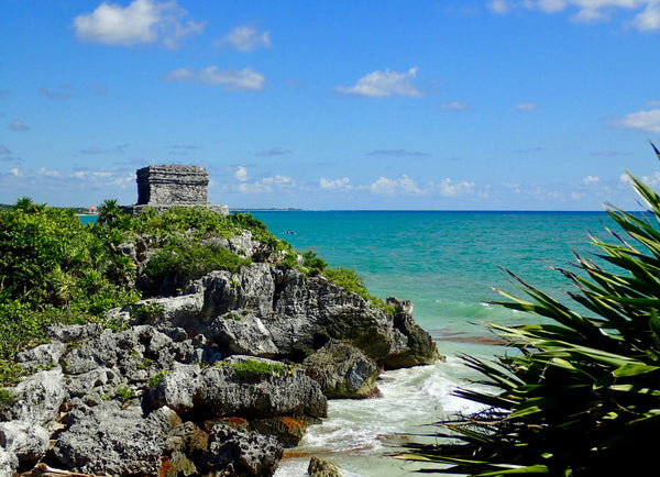
El Castillo is the tallest structure situated high on the cliffs above the sea. Although referred to as 'the castle,' it never functioned as one. The building was constructed at various stages in different time periods. The later addition of the top story as a temple includes the heads of a feathered serpent as influenced by the Toltecs of central Mexico.

Temple of the Frescoes is believed to have served both social and religious functions including an observatory and as a pilgrimage site for Maya women. The temple is located in the center of the site and includes many carved niches of a "diving god" or possibly Venus. Other adorning symbols relate to fertility including flowers, fruit, ears of corn and intertwining serpents. Photo by Carlos Delgado
Tulum is a sacred site. Many of the smaller buildings functioned as shrines or miniature temples often aligned with the heavens or near an important resource like fresh water. Altars are found throughout the various structures. Historians believe offerings were made as a means of connecting with the other worlds and deities.
The Maya were great astronomers and mathematicians accurately predicting celestial events in the future and the past. The most general word for a Yucatec high priest appears to have been ah k'in or 'calendrical priest'. When the Spanish Franciscan missionaries arrived in the late 16th century tasked with converting the indigenous of Mexico and the Yucatán to the Catholic faith, a grouping of texts was created, the Books of Chilam Balam, documenting the Maya religious traditions, ceremonies, and daily life. A great deal of information specifically pertains to the ancient Mayan calendar and the priests who maintained it. The Spanish used these documents to undermine and weaken the Yucatán Maya society contributing to the eventual abandonment of Tulum and other Maya sites.
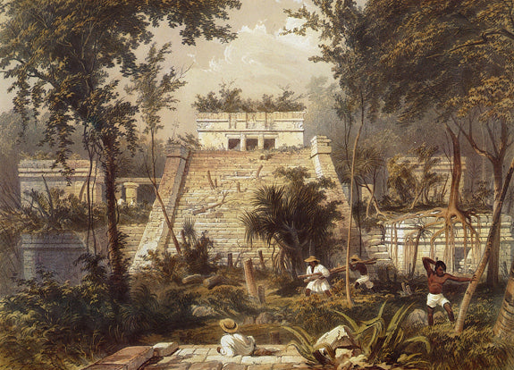
Explorer John Lloyd Stevens and artist Frederick Catherwood visited Tulum publishing this lithograph in a book about their voyage in 1843. wikimedia.org
Although the Spanish were able to conquer much of the New World, the Maya of the Yucatán held much of the jungled Carribean coast until the 20th century. During the Caste War of Yucatán, from 1847 -1901, Tulum's ruins became a rebel outpost and any foreigner traveling in the region risked their life. An autonomous territory was formed by the Maya and recognized by the British. The last skirmish between Mexico and the Maya was in 1933. The surrounding area from Cancun to Belize is referred to as Quintana Roo but is officially titled, Free and Sovereign State of Quintana Roo. It remained a territory until October 8, 1974, when the Mexican Republic granted statehood. To this day, Quintana Roo remains Mexico's youngest state.
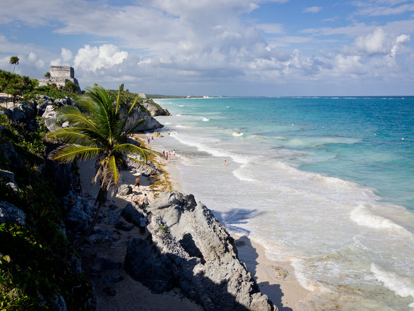
The beach below Tulum grants visitors access. Photo by Ken Thomas, wikimedia.org
Tulum Ruins are open to the public daily from 8 am to 5 pm. Cost of admission is 70 pesos, less than $5 US. Tours are available with a certified guide for an additional cost. Most hotels and resorts in the Yucatán area can arrange a visit from large tour groups to a private customized excursion. Remember to bring water, a hat, sunscreen, and a swimsuit as visitors are granted access to the private beach below the ruins.
*Cody and I enjoyed our stay at Diamante K Cabañas and Restaurant inside Tulum National Park. Click here for more information. Reasonably priced, attentive staff, fabulous views, a private beach, and tasty food.
Leave a comment
Please note, comments must be approved before they are published